

Mapping the Ardennes offensive proved much arduous than my earlier work on Normandy and D-Day.
Admittedly, I knew little about the Ardennes, cloaked as it was, under a tangle of oak, willow, conifers, poplar and beech. What I did know about this great campaign came from scattered readings and for having seen the great 1965 turkey The Battle of Bulge, the significantly better Battleground (1949), and the two-odd episodes of Band of Brothers which portrayed US airborne at the besieged market town of Bastogne.
Part of the challenges is that the landscape of the Ardennes is a difficult place to wrap the mind around, populated as it is with places with impossible names like Houffalize, Foy, Soy, Wiltz, Champs, Saint-Vith, La Gleize, the vaguely wookie-sounding Neiderwampach, Sibret, Butgenbach and a rather pleasant-sounding village named Bra.
The battles here were monstrous; the brainchild of a despot grasping at straws for a last victory which he believed would reverse the course of the war. However, the finer details of the battle contain an almost supernatural quality: of phantom, snowsuit-clad Germans passing in an out of US lines, of American paratroopers holding frozen ground against titanic German tanks appearing of the mist, of foxlike English-speaking Germans sowing discord behind the lines, of diehard SS commandos wielding captured US Army equipment and uniforms to punch through Allied lines and a fog which hung like a pall for the first nine days of the battle.
Yet, the alien, hard edges of the Battle of the Bulge are softened somewhat by the pop-culture icons who found themselves in the midst of this struggle — men like the late, affable actor Charles Durning, who possibly survived an SS war crime outside the town of Malmedy, and the author, Kurt Vonnegut of Indianapolis, who, as a member of the green US 106th Infantry Division, fell into the German bag after his regiment was overrun by swarms of Teutonic armor and infantry.
This, I suspect comes to down to our human need to identify something familiar out of the monochromatic visions which emerge from literature and photography. Arguably, cartography is one way to cut through this hermetic barrier. Words may have the ability to evoke powerful scenes, but maps have the power to crystallize text onto a landscape we can visualize in our mind’s eye.
—————
The initial set of three maps took over 30 days to create. Several contemporary books were consulted to figure out how events transpired, including Antony Beevor’s Ardennes 1944, which proved to be singularly useless. In the end, I went back to the original sources: US Army historical documents, manuscripts, dispatches and books including Hugh Cole’s excellent The Ardennes: Battle of the Bulge (US Army, 1965).


The Front Explodes


Allied optimism that the war would be over by the Christmas of 1945 was nearly quashed as Christmas approached and the war in Europe looked as though it had no immediate end in sight. The US First Army settled to rest and regroup in the Ardennes Forest in Belgium, an area considered as being a relatively quiet sector of the front. Many of its units were in strung-out shape after enduring relentless combat since the Normandy campaign. But in what was probably the greatest intelligence lapse by the Allies in the war, the Germans were able to assemble, in secret, three entire armies (or over 275,000 men) along the 60-mile long Ardennes front.


The Life and Death of Kampfgruppe Peiper

Events of the 1965 film The Battle of the Bulge largely depicted the movement west of the 1st SS Panzer Division, which had orders to reach to the Meuse River. In real life, the SS was badly delayed by the inability of other units to clear the way – a problem compounded by poor roads which were in no state to support an armored advance. On several occasions, commanders reported mud coming up the decking of tanks.
As the pressure mounted, the SS began to act on an order supposedly handed down from high command, instructing units not to take prisoners, lest they slow down the momentum of the advance. A series of atrocities by SS troops ensued, particularly by Kampfgruppe Peiper, led by an ambitious young veteran of the Russian front, 29-year-old Joachim Peiper.


Among the evocative photographs to come out of the Battle of the Bulge were these two images. Here, two paratroopers of the US 82nd Airborne Division bring a young SS captive in at the point of a Tommy gun. These pictures were taken at Bra, Belgium on December 24, 1944. (Both photographs taken by the Associated Press)
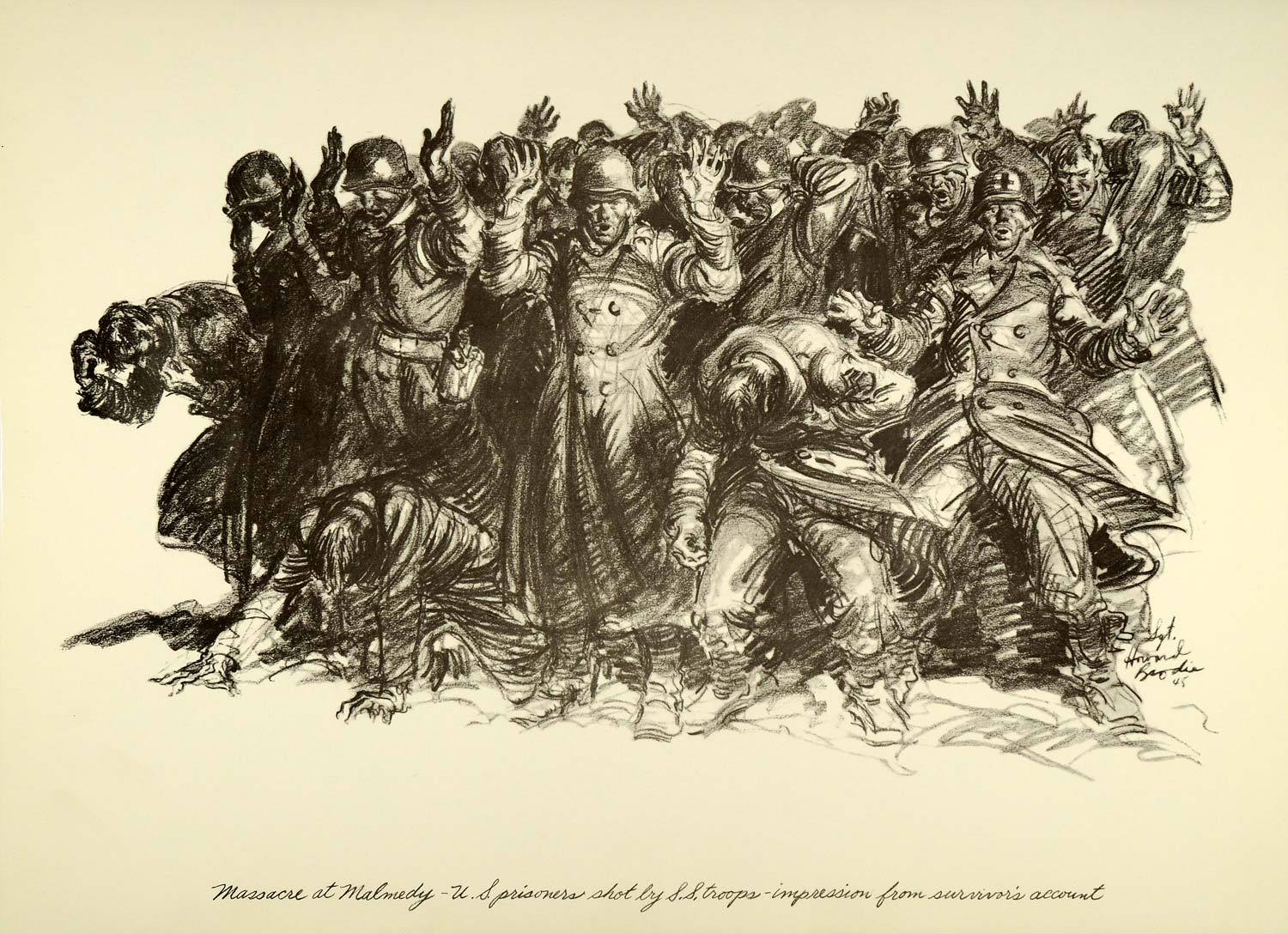 Sgt. Howard Brodie’s depiction of how the “Malmedy Massacre” went down.

The Bastion
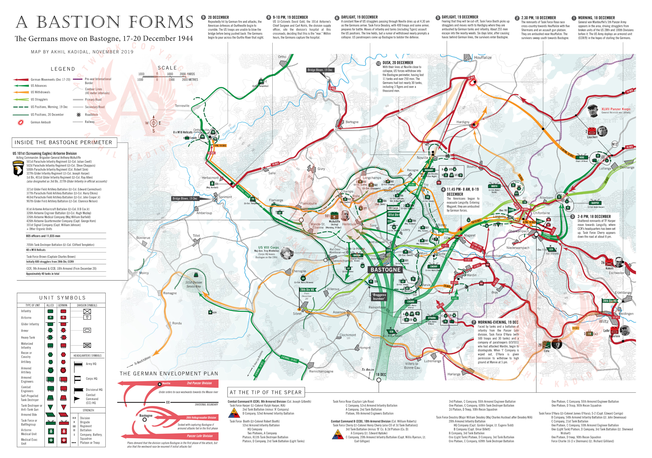
As the Germans swept deeper into the Ardennes, the Belgian town of Bastogne, occupying a key position on the rail and network in the region, came under threat. Bastogne was nearly undefended until the 48th hour of the German offensive. In desperation, the Americans rushed a tank unit (Combat Command R from the 9th Armored Division) to stall the incoming Germans until reinforcements could be pushed into Bastogne. The only other units available were paratrooper divisions recovering from an abortive campaign in Holland that September. The US 101st Airborne Division was alerted to advance into the sector, but being a parachute division, it had no attached armor and a grave shortage of bazookas.
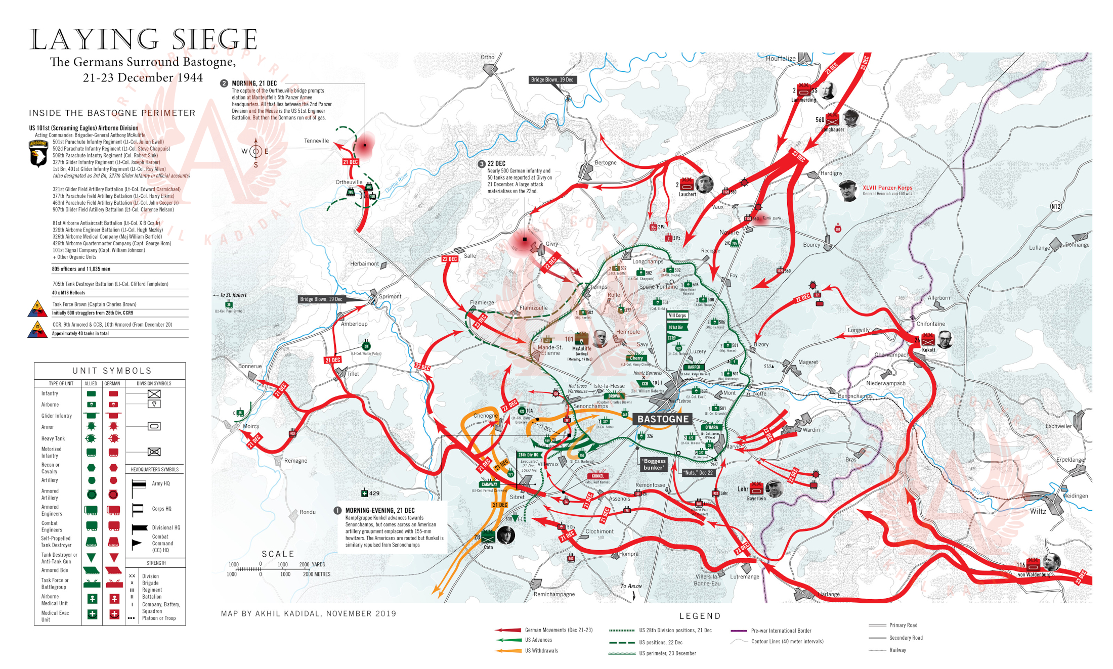

A second tank force (this time from the 10th Armored Division) also raced to defend Bastogne. By dusk on the 19th, the area around Bastogne was embroiled in combat. By December 22, American troops within the Bastogne perimeter realized that they were surrounded. Meantime, the Germans, torn between their desire to stay on course towards the Meuse River and their inclination to nullify Bastogne, mounted a series of penny packet attacks against the perimeter which achieved little and wasted valuable time.
 A group of paratroopers from the 101st Airborne Division get some hot chow near the frontline. The discovery of a large Red Cross warehouse within the Bastogne perimeter early in the siege, allowed the besieged paratroopers the luxury of hot pancakes on most mornings. (Corbis)

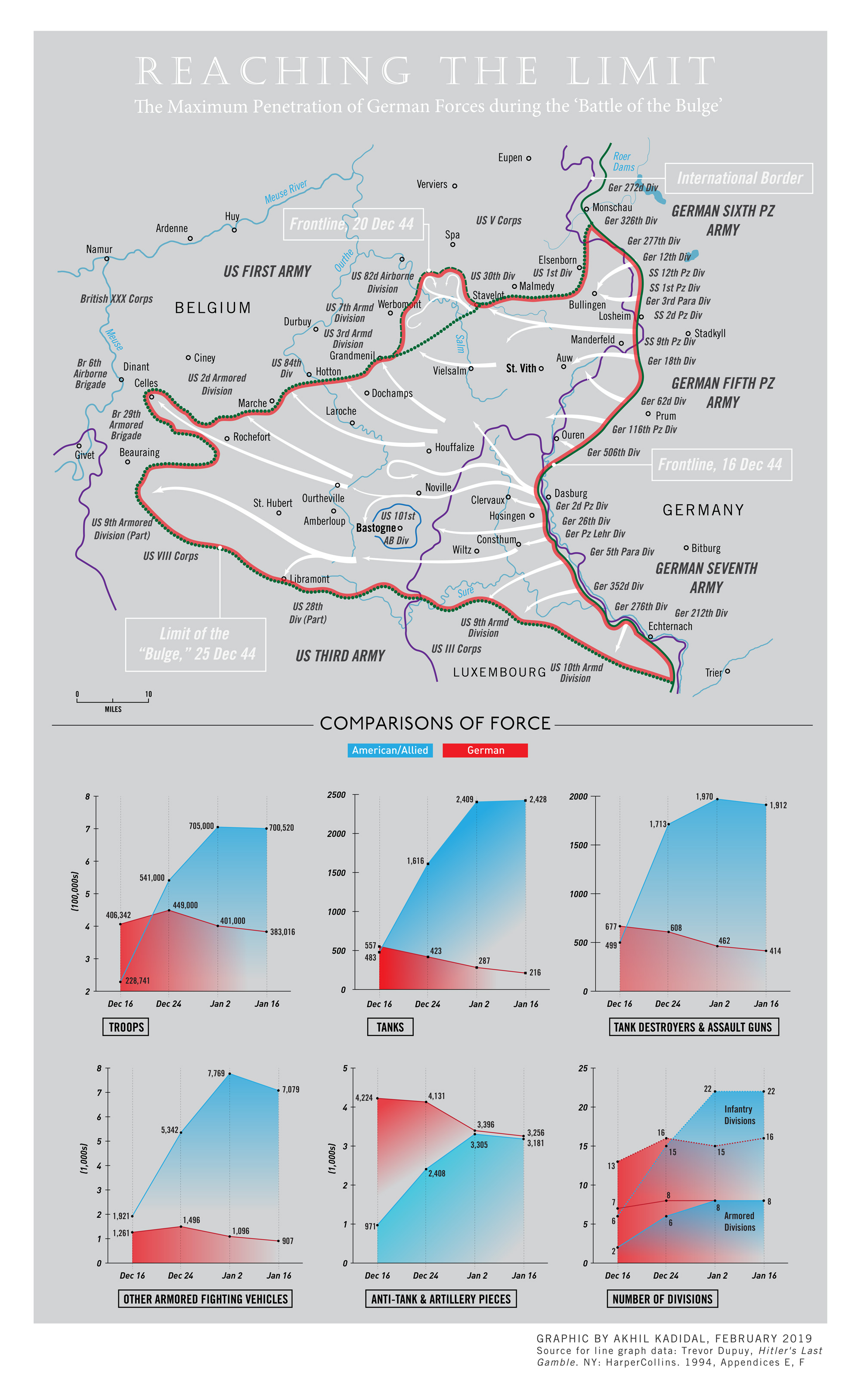
The Extent of the Bulge

The End of the Battle
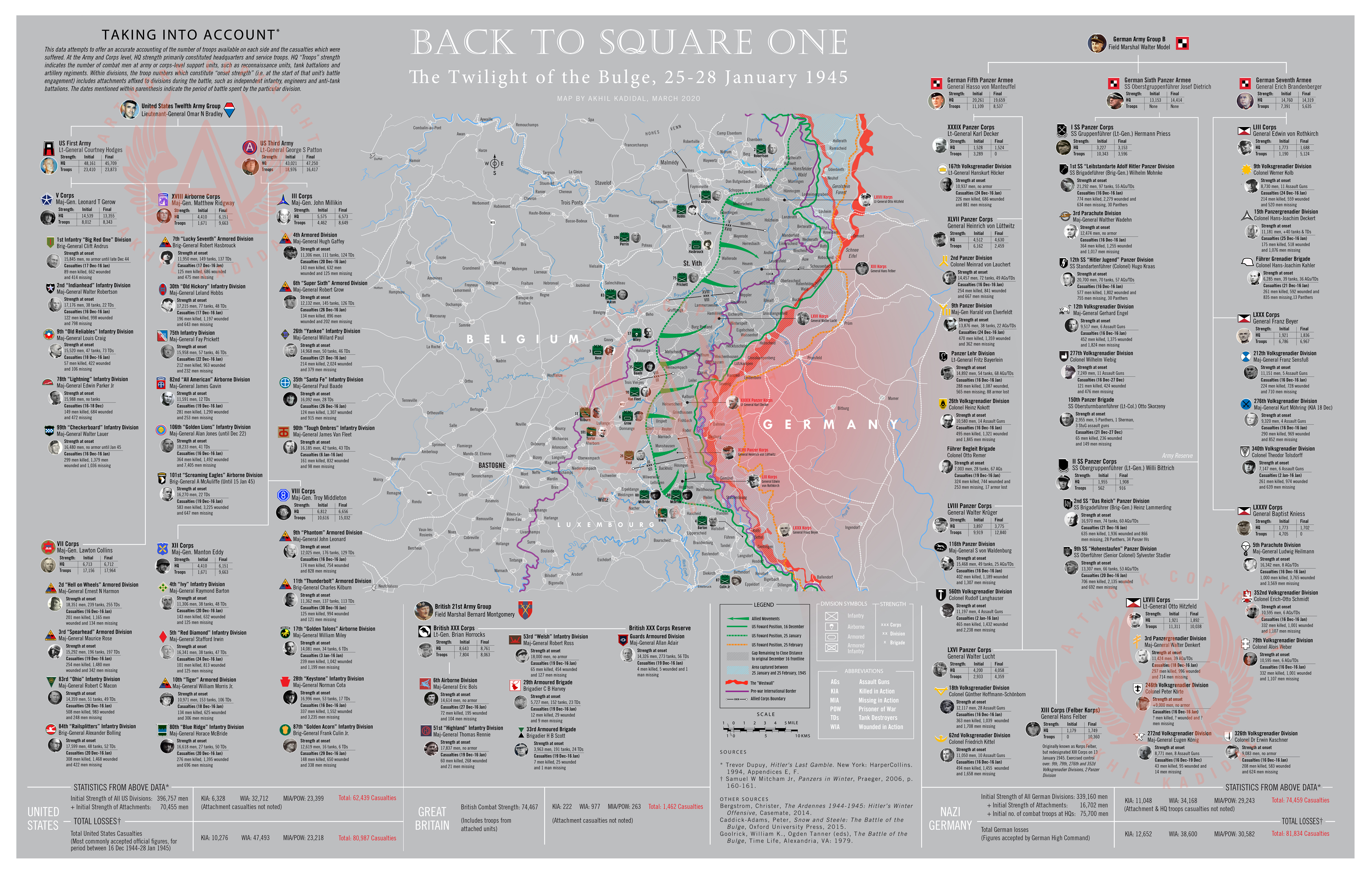
The Battle of the Bulge may have became more and more uninteresting even as it approached its twilight. However, it was fascinating to discover how little progress the Allies were able to make despite the gaining the initiative from December 28, 1944.
By February 25 (a month after the official end of the battle), the battle lines, on average, still amounted to less than five miles beyond the original US frontline of 15/16 December 1944. No doubt, this was the result of 20 battle-drained German divisions packed into a 60-mile front still being able to wield authority over the Ardennes section of the western European frontline.
When it came time to mapping the end of the battle, the obvious choice was to determine which side had suffered the most. It turns out there is no definitive answer to this. While official or accepted figures for both sides prove near equal, in the early 2000s, the US Department of Defense determined that American losses during the battle exceeded 104,000 men (including just over 19,000 men killed). There is no information on the source or the basis which was used by the DoD to arrive at these figures, which seem high.
In the graphic above, I have attempted to accurately chart casualties suffered by every division which participated in the battle. Much of the information is from Trevor Dupuy’s “Hitler’s Last Gamble,” although sometimes even Mr Dupuy’s comprehensive data appears to be not quite right.
Nevertheless, I believe this graphic will offer substantive clarity on the human cost of the “Battle of the Bulge.” By the way, FYI, this download is 5 mb.
![]() Still in the Works…
Still in the Works…
I’ll probably add two more maps to this series, including:
- The Battle of Noville
- The German advance to the Meuse (Dec 24-27)

Reblogged this on European Center of Military History and commented:
your maps are 101% :))))
Thank you!
still waiting for the continuity of the excellent magnificent maps of the Bulge, like end of battle, noville and advance to the meuse jpeg !!!
cheers and best wishes,
Hi Stuart, thank you for the interest. I have been temporarily sidetracked from the project by two things: the Covid pandemic and my attempts to complete a sprawling project on Normandy. I will try to finish the Bulge maps as soon as possible.
thank you, keep up the top of the notch works !!!
The maps are indeed excellent!
It seems the graphic of chapter 5 can’t be magnified. Can something be doen about that Akhil?
Overall it is refreshing to see this combination of art, photography and graphics. I very much welcome this and thank you for sharing.
Thank you, Marco, for your kind comments. I’m sorry but which chapter graphic cannot be expanded?
right beneath square 5 The end of the Battle.
It should be available now. I have no idea what went wrong. It used to be fine before.
yes it if fine now. Wow I could study his map all evening. Just keep amazing us Akhil :). Thank you.
Loved Villers Bocage.
The Bulge is a huge undertaking.
Criticism: the Alpine photo in part 1 cannot be Ardennes related.
Thanks for the comment, Jon. I have always found the Bulge to be a convoluted, confusing affair. But it’s fascinating at the same time. About the photo, I suspect it may have been shot state-side but I am not sure.
Hi Akhil, the anon post was me.
The Alpine pic looks non-US troops, except the 2 ammo bandoliers, but the rifles don’t look like M1s.
As for the Bulge, the most fascinating and essential segment is up north, not Bastogne. Elsenborn ridge is where the operation was thwarted.
Thanks for your interesting work. Jon
I need to go back and look at the picture in detail. The image was definitely in a pack of US-related images. I do believe they are US troops. I agree with you about the northern shoulder’s importance to the battle.
Thanks Akhil. The Alpine pic is definitely Europe, from the stone construction. My guess is Italy, maybe post VE Day. Possibly a 10th Mtn. Div. staged or training photo, if these are US GIs. I knew some old-timers from the 10th.
These are fantastic- I have currently acquired a soldbuch to a landser from the 79th VGD and I am desperately looking for agood map of their involvement in the Battle of the Bulge. I know that from December 11, 1944, the units were transported from Thorn to the new operational area. The division was initially the LIII. Army Corps assigned to the 7th Army as a reserve and finally to the LXXXV. Army corps fed in the Vianden area. From here the division took part in the Ardennes offensive. The division’s task was to use all available means to hold and expand the bridgehead at Bourscheid. They came up against the US 80th ID here. In the period between December 23, 1944 and January 14, 1945, the division had around 1,800 men in casualties that could not be replaced by equivalent personnel. On January 12, 1945, the division was assigned to the LIII. Army Corps and replaced the 212th Volksgrenadier Division in its section on January 17, 1945. During the night of January 20, 1945, the Bourscheid bridgehead was evacuated by the 79th Volksgrenadier Division. On January 30th and 31st, 1945, they retreated to the West Wall behind the Our. The division was deployed in the Dasburg area. On February 8, 1945, the division then took over a section near Gemünd and on February 15 a section from Gemünd to Bauler. Can you help? Thanks Sven
Hi Sven,
Thank you for your kind message.
Your query about the operations of the 79th VGD is very interesting. Unfortunately, I cannot commit to making a map about the battle of the Bulge at this time – for various reasons, including my day job.
If you send me your address, I will get in touch when I am ready to revisit this subject. These maps require a fair amount of research.
Thanks Akhil
Please do not rush. I understand that you are a busy man. I was just hoping that you had a map close at hand with the 79t vgd positions. Thanks again for getting back to me.
Hey Akhil
I looked over your maps again and I see I forgot to leave my email address, which is zimmermannsven878@gmail.com. Again if you have any great map work on the movements of the 79th VGD, it will be greatly appreciated. Kind regards Sven
PS- Really great work.
Thanks, Sven. At the moment, I am focused on Normandy and a Market-Garden related project. I haven’t encountered any 79th VGD data yet. When I get back to covering the Ardennes, I probably will. I will certainly check after I wrap up the above mentioned projects.
Wonder job on the maps and info graphics. Well Done!
These maps are amazing!
Fantastic work! The maps are first class.
The image of the US ski troops is in the Maratime Alps. There is a wonderful series of colour photos taken of the 551st there and I beleive this is part of that series.
Many thanks for the feedback. Interesting to hear about the 551st PIR. I need to dig into this.
Your work is unvaluable and amazing. Keep it up!!!
Many thanks, I appreciate the feedback!
Fantastic work and maps! One slight correction if I may; with regards to the “Bastion forms” and the “Laying ánd Lifting the siege” maps- 2nd BN 506th and 3rd BN 506th should be flipped. (2nd started in reserve and was pushed forward on the 20th whilst 3rd held Foy and surroundig areas and 1st retreated from Noville. From the 20th on 2nd filled the gap in the woods between Foy with 3rd on the left – on the other side of the N30 – and 501st on the rightside.
Keep up the great work! Much appreciated.
Kind regards,
Ruud
Thanks, Ruud. I appreciate your valuable feedback.
I double-checked the sources for the maps and you are of course, totally right. I corrected the unit locations. I will re-upload the maps to the site when I get the time.
Thanks for maps regarding the Battle of the Bulge, Akhil. My dad was in the 424th Regiment of the 106th Division, and you accurately indicated his position during the first few days after Dec.16. He awoke to the battle in Steinbrucke, and fought for several hours in and around Winterspelt before being ordered west over the Our River. He encountered many from Kittel’s 62 VG.
I have visited the area a few times and found artillery craters and foxholes. I appreciate your attention to detail!
Hi Doug, thank you for your kind words – and for your sharing your father’s story. I made those maps years ago, and at the time, I neglected to examine the ordeal of the 106th Division in greater detail because of other commitments. At some point, I will resume my research and try to bring out more on the division.
Let me know if you more info about the 424th regiment. Their story is a bit different from the other two 106th Division regiments (422nd and 423rd) which were captured early in the battle. Thanks again –
I appreciate that. I will reach out. Thanks.