A Day at the Beach: Normandy 1944

Masthead-Normandy


March 2021 Update: I am pleased to announce that an updated, corrected and more comprehensive look at the battle of Normandy is now online. Find it here. It encompasses the expansion of my research into the campaign. The number of maps are now +40 (a jump from the 19 or 20 found in this post). The site also hosts hundreds of high-resolution images, including aerial reconnaissance photos from the US National Archives, all laid out in narrative form.

In the blank, unexplored spaces of the ancient world, map makers set down warnings that “here be dragons.” In the modern world, dragons might not exist but ambiguity does.running

When an associate recently suggested a quartet of books revisiting the battle for Normandy for the upcoming 75th anniversary of D-Day in June, I realized that I had no desire to add to the existing span of literature on Normandy. To do so felt trite, conventional and despite the overwhelming heroic mythos of the campaign, boring, because it meant retreading ground already explored at length but hundreds of writers since 1944.

While I may be incapable of adding words, I have no compunction about adding art pertaining to the battle, and especially maps, because here is a medium capable of heightening clarity and through which a modicum of originality can be achieved even though the places have all been mapped a thousand times before since early humans began to wonder about the world around them, recording the lines, culverts and rises made by people and nature alike on parchment in order to quash our fear of the unknown. Swords and arrows, it turns out, are not the only ways to kill dragons. Structure and knowledge are equally potent.

For me, map-making, like music, is another form of communication, using a language made up of lines, hues and symbols to tell a story. Maps are meant to be things of precision and when they work, they invite the viewer to explore the world set in pixel or ink before them, allowing us traverse a landscape in our imagination and wonder what happened here or there.

Below follow my attempts to map the most important events in the three-month slog which constitutes the battle for Normandy. I have given myself until January 31st February 10 to complete the series in order to start an unrelated photography project on living spaces on the Indian subcontinent, partly inspired by the work of the living British artist, Doreen Fletcher, who paints the neighborhoods of London’s East End, even as gentrification threatens to expunge the character of the place. (Check out her work; it’s interesting)

In any case, here are the maps, with a handful of pertinent photographs and my thoughts. If you have comments or criticisms to make, I’m open to hearing them.

The below map, titled “Closing the Gap,” while posted out of chronological order in the following series, is possibly my favorite, with my dispensing of the usual NATO-style military symbols which are a staple of battle maps in favor of a self-devised system of icons and glyphs intended to compact unit designations. I think the end result is more attractive and effective in the way it conveys information.

Normandy - Falaise - Closing the Gap

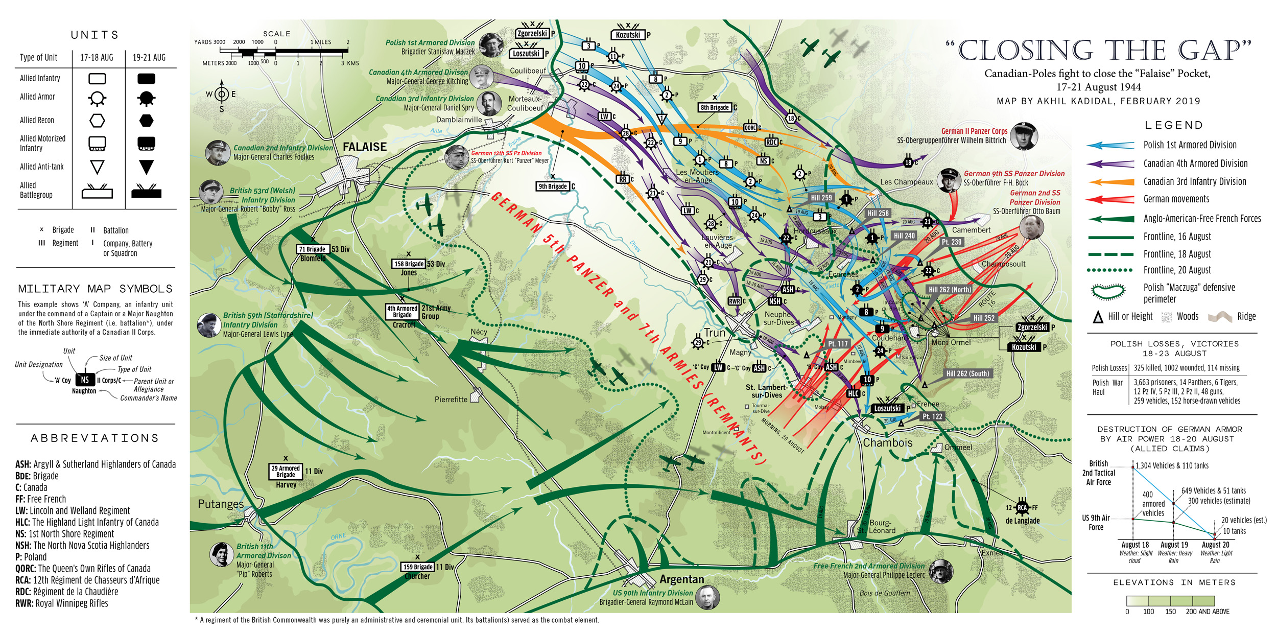
Building on the work of Major C.C.J. Bond, late of the Canadian Army, whose work was published in the official “The Victory Campaign,” Part III, this map includes research from several sources, including Terry Copp’s Fields of Fire (2003). I was particularly interested in analyzing the travails of the Free Polish Division around the town of Falaise (depicted using blue arrows) whose contributions have been largely ignored by postwar historians. The included figures of German motorized transport and tanks claimed as destroyed by the Allied air forces can be misleading in that claims by pilots often did not mirror reality. In fact, the Germans lost 133 tanks (most of which were abandoned), 701 “soft-skinned” vehicles and 51 guns in the so-called “Falaise Pocket,” in contrast to claims by pilots that they had blown up 6,251 vehicles within the pocket.

An Overall look at Operation “Overlord”

Normandy D-Day Map

The prospect of returning militarily to France sent the British Prime Minister Winston Churchill into paroxysms of fear and dread, haunted as he was by the specter of another “Dunkirk.” For years, he had put off a cross-channel invasion of western France by cajoling and manipulating the Americans into participating in military expeditions in the Mediterranean intended to take the Allies into Germany through the soft, underbelly of Italy. By 1943, however, the Americans were of the firm belief that Nazi Germany could only be defeated through a direct assault on Hitler’s “Atlantic wall” a metaphysical entity threading from Spain to Norway. The American planners of the 1940s knew well enough that walls, no matter how thick or tall, offered no impediment to determination and a plan began to coalesce, involving pitching twelve Allied divisions (roughly 156,000 men) into German-occupied Normandy, to hew an iron beachhead from which Allied troops could range deeper into Nazi-occupied Europe.

In retrospect, Churchill’s fears seem unfounded. He spent much of June 5 and 6 in a state of unbridled inner terror, fearing that the invasion, codenamed Operation “Overlord,” would fail, dealing the western alliance with a critical setback, and forcing them to marshal manpower for another invasion in late 1945 or 1946 — by which time Hitler could have used his western reserves to smash the Soviets on the eastern front. Yet, the bulk of Germany’s forces along the Norman coast were tired, rear-echelon units with substandard equipment. The best division in the area was the 12,734-strong German 352nd Infantry Division, which had almost no combat experience (50% of its officers were green while the rank and file was largely made up of teenagers from the Hannover area). Only the presence of a hardened cadre of veterans from the Eastern Front peaked the division’s fighting prowess to acceptable levels. The other divisions were worse, with the exception of the 709th Infantry under the experienced Lt-General Karl-Wilhelm von Schlieben, also a veteran of the Russian front.

Von Schlieben’s command, however, was less than stellar, being largely composed of men regarded as unsuitable for frontline service. The average age of a soldier in the 709th was 36 and their training had been minimal. Russian defectors padded out the infantry even though their combat effectiveness was questionable. The unit’s left flank, however, was bolstered by the 91st Airlanding Division, which although green, was better motivated and tough.

The Allied armada, which left England on June 5, would take 17 hours to cross the English Channel while Allied paratroopers flew out after dusk to secure the flanks of the invasion zone – west of the Norman capital Caen and on the Cotentin peninsula, in order to stem the flow of German reinforcements into the planned beachhead assault zone. At midnight, 13,348 Allied paratroopers began to descend onto Normandy, throwing the Germans into chaos. Then, just after dawn, at 6 am, the Allied invasion fleet hove into view off the Norman coast.

Sword Beach

A critically important sector, troops hitting “Sword” Beach were meant to roll up into the Norman capital, Caen (population 54,000), whose great road hub would have facilitated an easy advance deep into Nazi-occupied France and open the way to Paris, just 149 miles away.

The unit handed the task was the British 3rd Infantry Division, the oldest command unit in the British Army with exploits ranging back to the Battle of Waterloo in the 19th century. Bolstered by 4,000 commandos, a brigade of (212) Sherman tanks, and the paratroopers of the 6th Airborne Division on their right flank, the Third pushed ahead towards Caen on the morning of June 6, sweeping aside German resistance until the sole German armored division in the area, the 21st Panzer, placed itself between them and Caen at midday.

The 21st Panzer, once a fabled stalwart of the North African war was now a toothless tiger, replete with misfits and recruits — although 2,000 original members, having been hospitalized for wounds in North Africa two years ago, had returned to swell its ranks. Evidence of its diminished standing was borne out by the fact that it had until recently, been equipped with old French tanks captured in 1940, although by D-Day, it had been outfitted with Panzer IVs, a medium tank which was an even match for the Allied Sherman. Even its commander, Major-General Edgar Feuchtinger, behaved as though the running of this division was something of a chore, if not punishment. Accordingly, Feuchtinger spent more time lavishing attention on his mistress in Paris, than on working to get his division to full operational status. In fact, Feuchtinger was once again philandering in Paris when the invasion materialized, enraging his superior, Lt-General Hans Speidel, the Chief of Staff of Army Group B. As a chastened Feuchtinger raced back to Normandy on the afternoon of the 6th, the division activated itself and sent out patrols.

Troops from the British 3rd Infantry Division press on towards Caen on D-Day. (IWM)

British tanks and Infantry streaming towards Caen began to take heavy fire as they reached the Periers Ridge, a stretch of high ground before the villages of Periers-sur-le-Dan and Bieville. Instead of smashing through, the British infantry of the 1st South Lancashire Regiment and the tanks of the 13/18th Royal Hussars dug in. Aside from a smattering of German infantry and strung-out screens of antitank guns, there was virtually nothing between them and the city. They could have well been in Caen by mid-afternoon. But their leader, Brigadier Edward Cass, preferring to wait for reinforcements. It would prove a fateful decision.

Meantime, senior German officers were scrambling to deploy their armored reserves scattered around central and southern France. At 9 am, nearly two hours after the beach landings, Field Marshal Gerd von Rundstedt of OberKommando West, had attempted to rush the 12th SS (Hitler Jugend) Panzer Division and the elite Panzer Lehr Division into the invasion zone, only to be stalled by Field Marshal Alfred Jodl, the German Chief of Operations Staff in Berlin, who argued that only Hitler had the authority to move these units. But Hitler, a habitual late riser, was still asleep and would not awake before noon. When he did, he flew into a rage at the news of the Allied invasion. By when the armored units finally began to move, it was 4 PM.

By this time, British thrusts towards Caen and Lion sur-Mer had stalled, prompting them to give up on their plan to link up with Canadian troops fighting in the neighboring “Juno” sector. Rushing through this gap, tanks and infantry of the 21st Panzer reached the coast intact. “The future of Germany may very well rest on your shoulders,” a senior officer had told their commander, Colonel von Oppeln-Bronikowski. “If you don’t push the British back, we’ve lost the war.” Instead, the Germans were horrified to see a swarm of Allied transport aircraft tugging gliders headed in their direction at 6 pm. Afraid that they would be cut-off by gliders landing all around them, Oppeln-Bronikowski called the retreat. Caen, however, would remain in German hands for the next five weeks, becoming a thorn in the Allied side and costing the lives of thousands of troops before it eventually fell.

This map was arduous to make, in that it took nearly 10 hours to complete, because instead of separating the various component actions of June 6 into three entities — the airborne landings, the main beach assault and the push inland and the German counterattack — I sought to encompass every aspect of the eastern British sector into a single map. However, in comparison to my map of “Utah” Beach which can be found below, this map was also frustrating to make because of a paucity of information.

For example, I did not have the luxury of detailed information about the drop patterns of British airborne units from official British sources — unlike the US military which liberally proffers information about the activities of the 82d and 101st Airborne Divisions on Normandy’s Cotentin Peninsula. Movements of land forces were established through careful research and by consulting several books on Normandy, specifically Georges Bernage’s Gold Juno Sword (2007). The resulting map, I hope, offers a clear picture of events in the “Sword” sector, although, given its complexity, I feel myself searching for Waldo.

Continue reading “A Day at the Beach: Normandy 1944”

The War in Biafra

Biafra Mast

The following art is for a new research project, titled: The War in Biafra.

(Temporarily on hold until several other book projects are completed)

If you were a participant in the war, or were a witness in any way or form to the conflict, or happened to be in Nigeria during the critical years from 1964-70, worked for the Red Cross, the PR outfits or the churches, or even protested the conflict in the United States and Europe over continued British aid to Federalist Nigeria, or stood against the Biafrans, or simply have something to say, I am interested to hear your story. Drop me an e-mail by using the “contact me” page linked in the menu above or leave a message on this page.

All images are in medium resolution; click for larger picture.


What this is all about (a brief explanation): Look at world maps today and you will find no mention of the nation of Biafra. It has  suffered an attempt at being expunged from the consciousness of human history.

The country of Nigeria in West Africa, recently known for its e-mail scams, is at the center of this story. Essentially a British construct brought into a national identity without considering regional loyalties, Nigeria can best be identified as the unnatural union of three culturally disparate territories often at odds with each other — the largely-Muslim North, the traditionalist West and finally, the Christian East which in 1967, seven years after Nigerian Independence from Britain, christened itself as Biafra and broke from the Federation because of violent persecution. Biafra’s most numerous peoples are the Ibos, the so-called “Jews of Africa” because of their formidable intellect and perseverance but also as one historian recently argued, because of an ancient link to the tribes of Israel.

But the stunted potential of the Ibos has been written about in the past. One famous writer, Frederick Forsyth, was so committed to Biafran cause that he wrote one propagandized book on the matter and later published a bestselling novel about mercenaries who conquer a new African country for the Ibos (remember The Dogs of War?).

Nigeria, incensed by the Biafran secession, engaged in a police action which soon transformed into a full blown war, fought not only in part over oil in Biafra, but also over personal ambitions and British interests in policy and investment — reasons which gave the world its first prototypical image of the starving African child, and the combatants the ignominious honor of conducting the first modern war in Africa. It was also a war between two English-trained African armies, internationalized by mercenaries and adventurers, gun-runners, journalists, pilots, aid workers, the clergy and the World Council of Churches, who as the months wore on stepped in to aid the starving and a country.

Biafra Ph-3Biafra Ph-1Biafra Ph-12Biafra Ph-4Biafra Ph-8Biafra Ph-10Biafra Ph-5Biafra Ph-11Biafra Ph-9Biafra Ph-6Biafra Ph-2

Biafra Ph-7Biafra Ph-14Biafra Ph-21Biafra Ph-17Biafra Ph-16Biafra Ph-18

Biafra Ph-18cBiafra Ph-18bBiafra Ph-18dBiafra Ph-18eBiafra Ph-18aBiafra Ph-22

Biafra Ph-23

Biafra Ph-15

Biafra Ph-24

Biafra Ph-20

Biafra Ph-25

Biafra Ph-26Biafra Ph-27Biafra Ph-28Biafra Ph-18f

Divider-9

A Note on the Process: All art was drawn using Adobe Photoshop & Illustrator and are in the guise above for purely illustrative purposes on this site. The map, composed at 1:1,000,000 scale, took about 47 hours of work, spread over 5 days. It survived to see completion despite my working while on a three-day visit to a friend’s house at the other end of the state, in a house packed with overzealous little kids and hyperactive dogs. The version of the map posted is at medium-low resolution. (11-02-2011)

The Raid – Operation “Neptune’s Spear”


-click image to enlarge-

Okay, everyone has been following this bit of recent news, but facts and logic seem small in comparison to sensationalist hyperbole. Australia’s Herald Sun carries an action movie-style graphic here showing Bin Laden on the roof of his house, defiantly blasting incoming U.S. helicopters with automatic fire. The Daily Express‘ headlines included the now-discounted sub-head of Bin Laden “used wife as human shield,” mimicking disclosures by news-ravenous networks in America. The following is what is actually known:

————————————————————————

The helicopters and Navy seals did not take off from an airfield in Pakistan with the blessings of the Pakistani government. They instead departed in secrecy, from Bagram Air Force base in Afghanistan some 158 miles from Abbottabad in the dead of night, and flying low under the radar, reached their objective a little before 1 a.m. on the night of May 1. Because the standard MH-60 Black Hawk has a range of 373 miles on internal tanks we have to assume that this figure is the benchmark for all derivatives – at least in theory – and which would allow the aircraft the cover the distance without refueler support.

At least two of the helicopters were stealth-modified Black Hawks, carrying 12 Navy Seals each. The Army Times contains a convincing narrative of the new helicopter here. With its extra stealth equipment and heavy payload (12 fully-armed troops instead of the standard 11), it is possible that one of the helicopters crashed in part because it was so overloaded.

After the Seals landed, the opening of hostilities was marked by the destruction of the compound wall with explosives. Alarmed, Bin Laden’s courier, the same man who had unknowingly betrayed the location of the stronghold, now appeared from the door of the guesthouse and fired a weapon. He was instantly gunned down. He is possibly the only hostile combatant within the compound who actually managed to open fire on the Seals (a total of 19 people were present in the compound that night, 14 of which were women and children). Bin Laden was seen to look out of a window before ducking back in. The Seals found him in a room on the top floor, unarmed, but within reach of arms. In this era of state-sanctioned executions, nothing can be written off as a moment of callousness in the heat of combat. One sources states that Bin Laden was executed when on his knees; others say that he was shot as he faced the Seals. The photographic evidence which would complete the journalistic picture is still lacking – except for the Italians apparently, who have a photo and a copy of photoshop. (See end of post)

One person was apparently taken into custody after the raid, reported as one of Bin Laden’s sons. For this to be done, and to exfiltrate themselves, the Seals had to call in one of the backup (non-stealth, but infrared suppressor-equipped) Chinooks. Where had this machine been? Loitering nearby?

Bin Laden’s compound was at the center of the army town of Abbottabad. News outlets, parroting other news outlets have stated that the entire property is worth at least a million dollars – reinforcing the legend of a terrorist leader living “high on the hog.” In reality, the Associated Press valued the price of the land at $48,000 when it was purchased in 2005 on Al-Qaida’s behalf. Actual construction of the house and accompanying structures would not have been significantly higher – considering cheap third world labor that every outsourced victim and ex-employee should be familiar with. For instance, study picture below for examples of shoddy brickwork and architecture. Does this really look like a million dollar home?

Source: CBS News Website


Finally, considering Bin Laden’s presence in this active army town, how could his complicity with the Pakistan military possible be disavowed? The falsehoods came easily and apparently without any forethought. Bin Laden’s house is about 2,500 feet (0.47 miles) from the Army College, Pakistan’s equivalent of West Point. This is easily verifiable through Google maps. The Pakistanis instead claim that the distance is 2.4 miles.  On 5 May 2011, the Pakistanis stated that Bin Laden was “strapped for cash in his final days.” How could they know this without knowing something of the man’s business?

And so the story goes on. In the meantime, keep watching the news stands for more scathingly brilliant, completely factual journalism such as the examples below…

______________________________________________________

UPDATE: The MH-60K Stealth Black Hawk, 11 May 2011

The aircraft’s new tail and other enhancements are a result of mission-specific stealth kits adapted by the 160th Special Operations Aviation Regiment (SOAR). According to a classified source, the Black Hawk’s “tail and rotor are the most radar-sensitive areas of the helicopter and the sharply-edged shroud” revealed in photographs (see below) actually helps improve flight performance while reducing the aircraft’s radar signature.

Also, the kit used on the Black Hawks for the Bin laden raid involved “a new stealth-aiding windscreen, the removal of the large refueling probe that extends out from the front of machine,” and possibly the addition of retractable landing gear. The kit is an add-on treatment and not representative of a new stealth Black Hawk built from the ground up. No helicopter can use stealth with an absolute degree of success. The spinning rotors produce enough radar signature to give the game away – presumably why the raiding helicopters stayed low under the Pakistan air defense net to mitigate the limitations of their kit.

(Sources for this brief: Flight International 10-16 May 2011; Doug Richardson, Stealth Warplanes, London: Salamander, 2001.)

The controversial tail. (Source: The NY Times)

Somalia, 3 October 1993

-Click to see higher resolution –

This illustration was created using Google’s SketchUp 8 and Adobe’s Illustrator and Photoshop. I have always been fascinated by the techniques used by the larger newspaper organizations to create some of their art. Matthew Erickson did the original Blackhawk down graphic for the Philadelphia Inquirer to accompany Mark Bowden’s news reports. These days he is the deputy graphics director at The New York Times. His blog can be found at: http://www.ericson.net/content/   – But expect no revelation of secrets, apps used or an explanation of how the NY Times does its art. But he does have a small collection of interesting graphics.

A note on the software:

I discovered SketchUp yesterday and although it is ground breaking for its ability to generate 3D objects, I think it is really clumsy. Simple things that most people take for granted in illustrator (such as holding down the space bar to allow the mouse to move objects), are not easily accessible. I almost gave up in frustration this afternoon trying to build the base image for this picture. Still, SketchUp’s 3D quick rendering beats the painful drawing of multi-sided objects in Adobe Illustrator. I don’t know how Google does it. It’s large staff of engineers obviously have no clue how to make a user-friendly product but they certainly know their stuff.

Divider-5

Photographs

I decided to include this section for those seeking a little more information on the fiasco that was Somalia.

Parade at UNOSOM HQ at Mogadishu. The Americans, from the 10th Mountain Division, are led by a Pakistani Sergeant of Arms from PAKBAT (Pakistan Battalion).

Divider-9

To the Somalis, American troops might as well have been an army from another planet with their technological superiority. But the Somalis were also quick to realize that this dependence on technology left US Forces open to attack. Consequently, Warlord Mohammed Farrah Aidid ordered his militia to concentrate future attacks against the Blackhawks — accurately perceived as the weakest links in the opposition’s formidable array of military power.  Here, a Marine LCAC-22 hovercraft unloads its cargo in Somalia.

Divider-9


(LEFT) US Marines gather at the airport for protection duties. The armored vehicles in the background are LAV-25s, license-produced from Steyr-Diamler-Puch of Austria. (RIGHT) USMC PFC Anthony Mehia of New Orleans stands guard behind a barricade of sandbags at the US Embassy in Mogadishu. Note the field radio and the fully-loaded M249 5.56mm SAW light machine-gun — a weapon designed and originally made in Belgium.

Divider-9


(LEFT) Reminiscent of activities in the South Pacific during World War II, US Navy Seabeas work at the derelict Mogadishu airport. Here, a motor grader from the Naval Mobile Construction Battalion 40 (based out of Hueneme, CA) works on improving an access road beside the runway. (RIGHT) When a few Somali Technicals mounting 12.7mm Russian DShk heavy machine guns were spotted cruising the streets, locals called in the Marines who promptly arrived with a couple of LAV-25s, one armed with a TOW rocket launcher, to restore law and order. (Photo: USMC)

Divider-9


(LEFT) By 1993, the Somali air force looked like this – it’s entire compliment of aircraft reduced to rusting jets, beyond salvage. This photo is of a duo of Hawker Hunter T.77’s at Baidoa in January 1993. (United Nations) (RIGHT) The Mogadishu airport, busy once again, after it became a center of operations for the UN and Task Force Ranger. (Department of Defense)

Divider-9


Hearts and Minds. (LEFT) A Marine PR officer hands out leaflets to local Somalis. (RIGHT)  A Marine holding a Somali baby waits in turn for US Naval doctors to examine the child.

Divider-9


(LEFT) US Marines move from house to house in search of illegal weapons. The man climbing through the window is armed with some heavy ordnance in the form of an 84mm M136 AT4 anti-tank bazooka — a weapon first designed and manufactured in Sweden. Although the Marines spent their fair share of time in Somalia, attempting to restore peace and thwarting the warring clans, their activities were overshadowed by the operations of Delta Force and the Rangers who arrived much later. Incidentally, one of the US Marines who took part in these early operations was Warlord Mohammed Farrah Aidid’s own US-educated son, Hussein Farrah, who in 1996, took over leadership of the Habr Gadr clan after the death of his father.

(RIGHT) PFC Chris Boone of the 2nd Brigade, 10th Mountain stands guard at the Somali village of Belet Uen. (US Army)

Divider-9

Men from the 10th Mountain ride Somali-style through the streets of Kismayu, as part of a convoy composed of Americans and Belgians.

Divider-9


(LEFT) Canadians from No. 3 Commando, Canadian Parachute Regiment walk a patrol at Belet Uen. In the fore is a radioman. His weapon is an American-made M16A2. Faced with repeated thieving at their supply base, a group of irate Canadian paratroopers caught the suspected thief — a Somali, whom they subsequently beat and killed in custody. As news of the death spread, a horrified Canadian government resorted to the radical step of disbanding the entire regiment — a unit which had been in existence since World War II.

(RIGHT) An Italian Bersaglieri infantryman from the elite San Marco Brigade interacts with Somalis at a local feeding station outside Mogadishu. As members of the former colonial power, Italian troops often overlooked or did little to halt acts of Somali crime, which infuriated other members of the UN mission. The trooper is armed with a BM59 7.62mm assault rifle, an Italian modification of the venerable American Garand rifle of WWII.

Divider-9


(LEFT) Members of the 10th Mountain confer with a Pakistani Captain whose troops have suffered an ambush. (US Army) (RIGHT) 10th Mountain troops have an impromptu meeting with Belgian paratroopers (wearing maroon berets). Many in the 10th Mountain were also qualified airborne troops, so they had something in common with the Paras. Here they discuss tactics with the Belgians who had been in-country longer. (US Army)

Divider-9


(LEFT) A 10th Mountain trooper, armed with an M16A2 and M203 grenade launcher attachment patrols a Somali village. (RIGHT) 10th Mountain soldiers unload heavy ammunition at their advanced base at Baidoa while a Belgian Para looks on.

Divider-9


(LEFT) An Australian infantryman watches as a food truck arrives at a feeding station. The trooper is armed with a distinctive, plastic-cased 5.56mm Steyr Aug assault rifle (another import from Austria). (Right) A view from the Ranger-occupied section of the airfield, looking out at the dispersal.

Divider-9

A Blackhawk prepares to dust-off. Most in-country Blackhawks were equipped with the External Stores Support System (ESSS), allowing them to carry extra fuel (as in this case) or rockets. (US Army)

Divider-9


(LEFT) A US Marine Patrol travels through the bullet-scarred streets of Mogadishu. (RIGHT) A 10th Mountain security patrol takes a breather in the Somali bush. The radio operator carries his equipment in an olive-drab Alice Pack, whose uncomfortable original strapping which must have played havoc with his patience. (US Army)

Divider-9


(LEFT) Marines wait by the rear entrance of their AAV “Amtrack,” anxious at the noise of gunfire crackling in a nearby neighborhood. (RIGHT) Ranger Keni Thomas flashes a broad smile for the camera.  Keni, one of the combatants in the Battle of Mogadishu (or the “Day of the Rangers” as it is known in Somalia) later made prominent appearances in PBS Frontline and History Channel documentaries on the battle.

Divider-9


(LEFT) The US Embassy at Mogadishu, abandoned during the Somali Civil War that toppled the Somali Dictator, Siad Barre, but later reclaimed by the American contingent of the United Nations. Here, tents of the Quick Reaction Force (QRF), primarily comprising the 2nd Bn, 14th Infantry of the 10th Mountain Division, appear within the embassy compound. Although the building itself was badly gutted, the compound and the area beyond the embassy formed the core of QRF headquarters. (Department of Defense)

(RIGHT) The scarred, hollowed-out remains of the Villa Somalia, home to Somali dictator, Siyad Barre, during his regime. When Barre was driven out of Mogadishu in January 1991, rebel troops ransacked the hilltop villa, discovering extensive surveillance footage and miles of magnetic tape recordings of telephone conversations. (Department of Defense)

Divider-9

Members of Bravo Company, 3rd Battalion, 75th Rangers pose for the camera in Somalia. (Department of Defense)

Divider-9


(LEFT) The Olympic Hotel, across the street from the target building. (Department of Defense) (RIGHT) The only picture snapped during the October 3rd battle was this image, showing Captain Steele’s column under attack.  (US Army)

Divider-9


Michael Durant’s Super 6-4. (LEFT) Durant (far right) with his crew. (RIGHT) The wreck of Super 6-4. (Both photos: Department of Defense)

Divider-9


(LEFT) A freed Michael Durant is carried by stretcher to an aircraft destined for Landstuhl, Germany. The two men gripping the far side of the stretcher are Delta Force operators. Malnourished and desperate for familiar food, Durant promptly ordered a large Pepperoni pizza with extra cheese while still en-route.  The pizza appeared after he landed, hand delivered by US Air Force crewmen who also picked up the tab — unfortunately the doctors forbade Durant from tasting a single slice, owing to his liquid diet.

At the hospital, Durant was reunited with his family and treated for his injuries (including a fractured right cheek, a broken thigh, a shrapnel wound to his arm and a compression fracture of the lower vertebrae).  (Department of Defense)

(RIGHT) Ranger survivors of the Battle for Mogadishu gather in memory of their lost comrades on October 5th. (Department of Defense)

Divider-9


(LEFT) Aerial reconnaissance photograph of Mogadishu, on the day of the raid, 3 October 1993. (Department of Defense) (RIGHT) A United Nations Refugee Agency (UNHCR) map of Mogadishu. Although this map is from 2007, it shows the location of the Olympic Hotel and other important landmarks. (Note — File size is 3.8 mbs) (UNHCR)

Divider-9